


- Abridge and Kaiser Permanente debut Care Signals

- Built to Serve: The Day That Reminds Us Why We Chose Dentistry
- Journalists Catch You Up on Fauci Hearing, Peptides, and Kids’ Caffeine Consumption

- CMS finalizes 2.3% hospital pay bump, mandatory joint replacement model: 9 things to know
- How ambulatory shifts are reshaping perioperative strategy
- Cyclosporiasis cases top 18,000: 3 updates
- How Allegheny Health Network Strengthened its Foundation for IV Compounding Safety with Automation and Standardization¹
- Health plan customer service reps have AI in their ear
- Centene’s buyouts could have a $315M+ price tag for the rest of the year
- Medicare pay cut sparks specialty battle over skin cancer care
- Cardiovascular Institute of New England provides notice of data incident
- CMS locks in 2.3% inpatient hospital base pay increase, nudges back CJR-X Model start date
- Why autonomy — not just capital — is winning over cardiologists
- The $36 vs. $95 problem: How RVU negotiations are skewing physician pay
- Mississippi hospital board member, former CEO remembered as advocate for rural communities
- Pennsylvania SUD treatment locator reaches 146K users
- Top 10 dental, DSO stories in July
- Ohio youth treatment facility faces scrutiny over reported abuse: 8 notes
- What dental leaders told us in July
- Urban hospital closures and net change, by state
- ADSO sues Colorado Dental Board over practice ownership rule
- New patient acquisition is the top growth driver for dental practices: Report
- 20 new behavioral health projects to know
- Nurses, patients protest North Star Health Alliance ASC closure
- No Surprises Act under attack by payers: 8 things to know
- Dental staffing wages up 23% since 2021: ADA
- AtlantiCare appoints anesthesiology, gastroenterology physician leaders
- Consumer dental spending up 24% over 10 years: 5 stats to know
- Baylor Scott & White joint venture expands outpatient behavioral health services
- 5 DSOs making headlines
- VA to explore GLP-1 treatment for alcohol use disorder: 4 notes
- A $5B wave of M&A hits the ASC industry
- FTC Sues Hims & Hers Over Health Privacy And Billing Practices
- 145 physician medical groups led all healthcare M&A sectors in Q1
- 10 new ASCs in July
- Healthcare exec, telemedicine company owner sentenced for $35M DME fraud scheme
- Amylyx demystifies post-bariatric hypoglycemia with patient education website
- What Dad Eats Before Conception May Influence Baby's Health
- Family History Plays Role In Genetic Risk For Breast Cancer, Researchers Find
- A look at employers' attitudes toward ICHRAs
- Revised 340B Rebate Model Pilot Program moves forward, despite provider pushback
- Function Health lands $450M in growth financing to scale tech-enabled preventive health
- Daiichi Sankyo flags accounting error, as shares tank despite revenue beat
- AbbVie's Skyrizi shrugs off new competition as it thrives in growing psoriasis market
- Op-ed: Hospitals on the edge, a time for CMS to do no harm
- Daily Routine Key To Good Health, Study Says
- Alignment Healthcare boasts 32% revenue jump in Q2, lifts 2026 outlook
- Xpovio mulligan in endometrial cancer comes up short as Karyopharm presses on in myelofibrosis
- Psilocybin Therapy Helps Ease Veterans' Severe PTSD, Pilot Study Finds
- Newsom Reverses On Long-Sought Paid Leave Benefit For California Teachers
- Nicotine Levels Are Rising Among Teens Who Vape, New Study Warns
- The Newest Federally Recognized Tribe Wants Better Healthcare. It May Be On Its Own.

- They Worked To Protect Public Health. Now They Want the Public’s Votes.

- 27 new behavioral health study findings to know
- 21 state behavioral health policy updates
- What will fuel the next wave of DSO growth
- Dentists’ biggest staffing headaches
- Shionogi makes the call on COVID pill Xocova TV spot
- Psilocybin-assisted therapy reduced PTSD symptoms: 3 notes
- Fierce Pharma Asia—Legend CEO exits; Merck’s hush-hush PD-1xVEGF plan; Otsuka’s novel ADHD nod
- Psychedelics, peptides and GLP-1s
- How 'physician-led' care team models tackle primary care's workforce problem
- How 7 systems divert behavioral health patients from the ED
- WellSpan Health, Hippocratic AI ink ‘multi-year’ partnership with plans to co-develop clinical AI agents
- Kaiser faces complaint over automated behavioral health triage system
- Free research hub Nila aims to demystify menopause, other hormone conditions
- Scientists Defend Fauci's Pandemic Work As Senate Hearing Turns Bitter
- Pfizer takes Litfulo to regulators in vitiligo challenge to Incyte, AbbVie
- Study Questions Effectiveness of Antihistamines in Easing Eczema
- Vaping Is Likely Reshaping The Future Of Cancer In The US, Study Argues
- Weekly Rundown: Counsel Health rolls out white label AI care platform; Community Health Network launches MyChart AI assistant
- New CEO Garijo sketches out vision to reverse Sanofi's fortunes as Q2 delivers impressive sales beat
- Alnylam shares tank 29% as Amvuttra disappoints with ATTR outlook cut for 2026
- Waystar boosts 2026 outlook as AI-powered RCM solutions gain traction with providers
- YouTuber MrBeast welcomes Amgen to the channel, kicking off pediatric cancer funding effort
- Booming Dupixent sales fuel Regeneron's biggest quarter since pandemic
- Sugar Consumption Early In Life Linked To Increased Dementia Risk, World War II-Era Data Show
- Work Stress Harming Middle-Age Sleep, Study Says
- RFK Jr.'s Gardasil litigation ties subject to fresh lawmaker scrutiny after Merck settlement
- Bristol Myers delays Cobenfy Alzheimer’s psychosis readout again amid another quarterly beat
- Hospice's Bad Reputation Amid Fraud Crisis Will Hurt Patients, Industry Experts Warn
- Cell Phone Ownership Linked To Lower Reading Skills In Elementary Students
- Listen to the Latest ‘KFF Health News Minute’

- Abortion Drug Law in Louisiana Heightens Hemorrhage Risk for Pregnant Patients

- Medicaid Insurers’ Contracts on the Line in Tight Governor’s Race

- Teladoc Health trims 2026 revenue forecast amid challenges with BetterHelp insurance shift
- Cigna CEO: Express Scripts seeing 'significant early interest' from clients for new rebate-free PBM model
- Viatris runs into FDA roadblock after advertising on-the-go use of cystic fibrosis inhaler
- Sanofi’s new CEO ‘looking deeply’ at late-stage pipeline as clinical clearout continues
- FTC sues Hims & Hers over data privacy, billing practices
- CMS' proposed 340B reimbursement cut—who wins, and who loses?
- Virtual care helps patients improve their gambling disorder symptoms, Birches Health finds
- Case Western Reserve University launches next-generation healthcare leadership program
- Lilly, Resilience commit $750M to boost US diabetes, obesity med production
- CMS ending Medicare Part D subsidy program
- Red Cross Declares Rare National Blood Supply Crisis Amid Summer Shortfall
- Not Just Pregnancy Fatigue: Could It Be Sleep Apnea?
- More Women Drinking During Pregnancy
- Wellstar Health System lays off 761 corporate, administrative staff
- Biogen flips '26 guidance from expected decline to sales increase
- Teva’s innovation engine offsets generics slump, leaving one analyst ‘shocked’ by Ajovy’s surge
- Talking To Your Baby? Eye Contact Is Key To Language Development, Experiment Shows
- Boosted by CMS settlement, Incyte expects Opzelura to cross $1B in 2026
- Leapfrog launches expanded ASC public reporting program
- Cyclospora Boosts Fears That Deadlier Foodborne Outbreaks Are Ahead
- DoorDash, GrubHub Delivering Junk Food To 1 In 4 Teens During School Hours
- Uninsured but Undaunted, a Surgical Patient Searched the Globe for a Deal

- Trump Has Quietly Throttled an Agency Devoted to the Safety of American Healthcare

- Hospice’s Bad Reputation Amid Fraud Crisis Will Hurt Patients, Industry Experts Warn

- Humana plans more market exits for 2027, CFO says
- PMCPA sanctions melatonin drugmaker over misleading information
- CG Life embraces next-gen era in merger with AI-native agency The Considered+AI
- How 2 FDA citations complicate Hengrui, Elevar’s push for liver cancer combo approval
- Fifth Death Reported In NYC Legionnaires' Disease Outbreak
- Many Young Adults Aren't Ready To Manage Their Own Healthcare, Poll Finds
- Can A Daily Multivitamin Help You Stay Active As You Age?
- Stellarus launches AI-powered health plan customer service representative copilot
- Prebiotic Soda Health Claims Questioned In New Nutrition Study
- Family-Based Childhood Obesity Program Helps Kids Cut Weight, Become Healthier
- To Afford Aging In Place, Older Adults Turn To 'Golden Girls' Housing
- Breakfast Can Help Teens Make Better Food Choices Throughout Their Day, Study Says
- Newsom Reverses on Long-Sought Paid Leave Benefit for Teachers in California

- FDA Panel Backs Two Peptides For Compounding, Rejects One
- How Accurate Are Photo-Based Calorie Apps? 4 Are Put To The Test
- Popular School Cafeteria Meals Need An Update To Meet Healthy Food Standards, Researchers Say
- Ovarian Syndrome Quadruples Heart Disease Risk In Women, Major Study Concludes
- Weed-Killing Chemical, Glyphosate, Linked To Premature Births In Humans, Study Says
- 'The Child Is Terrified': Doctors On Front Lines Of Measles Comeback Speak Out
- 'Yo-yo' Weight Loss Linked To Decline In Muscle Mass
- FDA Advisers Dismiss Safety Warnings, Back Four Peptide Treatments
- Frequent Marijuana Use Linked To Higher Stress Hormone Levels
- Back Pain? Try Swimming, Study Says
- Ozempic Cuts Down Calorie Intake For At Least A Year, Even If Hunger Returns, Trial Finds
- Money Problems Might Make Your Brain Old Before Its Time, Study Suggests
- Black MS Patients Dying Younger Than White Ones, Study Finds
- Headstands and Summervaults: A Statement on Crypto Vaults and Lending Strategies
- Remarks at the Small Business Capital Formation Advisory Committee Meeting
- Seeking Public Comment on Seeking Public Capital: Remarks Before the Small Business Capital Formation Advisory Committee
- Remarks to the Small Business Capital Formation Advisory Committee
- Statement on Regulation E-Delivery
- Paper Taper: Statement on Proposed Regulation E-Delivery
- Statement on Proposed Regulation E-Delivery
- Senate HELP committee advances nominees for CDC director, HHS preparedness head
- Remarks before the American-Hellenic Chamber of Commerce
- Remarks at the Society for Corporate Governance Conference
- Zimmer Biomet to Hire 500 in India as New Bengaluru Technology Centre Drives AI and MedTech Innovation
- AdaptHealth Investigates Data Breach After Social Engineering Attack, Possible Link to ShinyHunters Emerges
- Statement on the 2026 Regulatory Agenda
- Applying Agentic AI to Healthcare Delivery: The Key to True Transformation

- From Compliance to Clinical Action: Fixing the Broken Loop in Post-Market Surveillance

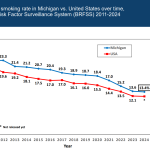
Michigan healthcare freedom community forum

The folks who want to control every mud puddle are teaming up with health departments everywhere.
All they want is to map all the things - for your health, you understand.
What could possibly go wrong?
2024 Summer Program in Population Health Course:
Using GIS to Understand Population Health
Registration: Register before May 1 to take advantage of the early bird special!
- Early bird cost before May 1: $400
- Cost on or after May 1: $500
- Special student rate: $100 Students eligible for the discounted rate include full and part-time undergraduate, graduate and doctoral students from any college or university in Ohio.
Please email Samantha Hicks at hicks.598@osu.edu for more information on how to receive the student rate or to register by bulk or with a purchase order.
Dates/Times: Thursday, May 30 & Friday, May 31 from 8:30 am – 5pm both days
Instructors:
Jesse Plascak, PhD, MPH
Director, SPACE (Socio-sPatial attributes and actions to Achieve Cancer Equity) Lab
Assistant Professor, Division of Cancer Prevention and Control
The Ohio State University
Elizabeth Ghias, MS
Program Coordinator, SPACE Lab
Comprehensive Cancer Center, Cancer Control Program
The Ohio State University
Course Description:
A geographic Information System (GIS) is designed to create, manage, analyze, and display data with locational information. Within a GIS are powerful and flexible tools that are often used by public health practitioners and scientists to better understand health-related resources, risks, and outcomes. This course offers an introduction to GIS and how it is used in population health to better understand the relationships between the environment, people, and their health. Topics include: the geographic nature of population health, types of spatial data and the management and integration of spatial data into health research, visualization and mapping, and basic spatial analysis techniques. The practical component of this class involves hands-on experience with GIS apps with a focus on ArcGIS. Participants will learn basic skills required to use and understand common GIS applications within public health departments.
Please note that the facility does not have computers onsite. Participants will need to bring their own laptop with access to ArcGIS Pro with ArcGIS Business Analyst. For a 21-day free trial for ArcGIS pro, go to https://www.esri.com/en-us/arcgis/products/arcgis-pro/trial/professionals and for ArcGIS Business Analyst go to: https://www.esri.com/en-us/arcgis/products/arcgis-business-analyst/trial/professionals within 3 weeks of the course start.
Course Objectives:
- Explain how geographic and spatial methods contribute to the understanding of public health
- Demonstrate basic data management skills and knowledge of sources of spatial data for public health purposes
- Create effective maps to visualize and communicate public health data
- Apply basic GIS operations to create new information and insights from spatial data
- Define and analyze spatial autocorrelation
- Explain and estimate geographic accessibility
- Acquire technical skills in the use of ArcGIS Pro software
Continuing Education & Contact Information:
Approval for continuing education credits is pending for Certified Health Education Specialists (CHES/MCHES), Registered Environmental Health Specialists and those Certified in Public Health.....
No privacy, no freedom.
This might be one to mention to your state legislators.
Get MHF Insights
News and tips for your healthcare freedom.
We never spam you. One-step unsubscribe.
Sponsors

J & DE Family Charitable Fund

Friends
of MHF
Kelly Grotendiek
Philip Harbach
Dale Johnson
Drs. Jeffrey and Joni Jones
Vickie Kahle
Tammy Kipen
Marlin & Kathy Klumpp
Melanie Kurdys
Ruth Nobel
Patrick Peterson
Stephanie Poortenga
Jeanne Smit
Ben and Hope Staal
John Tuinstra
Jacki VanHuis
Sandy Walker
Sign Up for MHF Insights to keep up on the latest in Michigan Health Policy

